Räumliche AuflösungSpatial resolution
Deutschlandweites Raster in ETRS89 / LCC Europe (EPSG:3034).Nationwide German grid in ETRS89 / LCC Europe (EPSG:3034).
hostrada4py verbindet zwei regionale Wetterdatenbasen in einem Python-Workflow: hochaufgelöste stündliche HOSTRADA-Daten für Deutschland und dreistündliche CERRA-Reanalysedaten für ganz Europa — für Standorte, Karten, Routen und Simulationsanwendungen. hostrada4py combines two regional weather-data sources in one Python workflow: high-resolution hourly HOSTRADA data for Germany and three-hourly CERRA reanalysis data for all of Europe — for locations, maps, routes and simulation applications.
DWD · Climate Data Center
HOSTRADA steht für hochaufgelöste stündliche Rasterdaten. Der vom Deutschen Wetterdienst veröffentlichte Datensatz ist eine klimatologische Referenz für Deutschland und eine wichtige Grundlage der technischen Klimatologie, unter anderem für die Entwicklung und Aktualisierung von Testreferenzjahren. HOSTRADA stands for high-resolution grids of hourly variables. Published by the German Weather Service (DWD), the dataset is a climatological reference for Germany and an important basis for technical climatology, including the development and updating of test reference years.
Deutschlandweites Raster in ETRS89 / LCC Europe (EPSG:3034).Nationwide German grid in ETRS89 / LCC Europe (EPSG:3034).
Stündliche Werte in UTC, monatlich um neue Daten ergänzt.Hourly values in UTC, extended with new data every month.
Geeignet für historische Analysen, typische Jahre und Extremereignisse.Suitable for historical analyses, typical years and extreme events.
Die Felder basieren überwiegend auf der Interpolation von Messstationsdaten. Je nach Parameter bezieht der DWD zusätzliche Satelliten- und Klimamodelldaten ein, um einen konsistenten Datensatz zu erzeugen. Besonderes Augenmerk gilt der städtischen Wärmeinsel und der Temperaturverteilung in orografisch komplexen Regionen. The fields are mainly based on interpolated weather-station observations. Depending on the parameter, DWD also incorporates satellite and climate-model data to create a consistent dataset. Particular attention is paid to the urban heat island effect and temperature distributions in orographically complex regions.
Copernicus Climate Change Service · C3S
CERRA — die Copernicus European Regional ReAnalysis — rekonstruiert meteorologische Bedingungen räumlich und zeitlich konsistent für den europäischen Raum. Durch die Integration in hostrada4py stehen die bewährten Auswertungen für Punkt, Fläche und Route nun auch grenzüberschreitend zur Verfügung. CERRA — the Copernicus European Regional ReAnalysis — reconstructs meteorological conditions consistently across space and time for the European domain. Its integration into hostrada4py extends the established point, area and route workflows across national borders.
Ein einheitliches regionales Raster für den gesamten europäischen Modellraum.A uniform regional grid covering the full European model domain.
Dreistündliche Analysedaten für zeitlich konsistente Klima- und Wetterverläufe.Three-hourly analysis data for temporally consistent climate and weather sequences.
Für historische Vergleiche, Extremereignisse und europaweite Langzeitanalysen.For historical comparisons, extreme events and long-term analyses across Europe.
Von Nordafrika bis über Skandinavien sowie vom Atlantik bis zum Ural.From northern Africa beyond Scandinavia and from the Atlantic to the Ural Mountains.
Dreistündliche Klimawerte für frei wählbare Standorte in Europa.Three-hourly climate values for freely selected locations across Europe.
Räumliche Felder und Gebietsauswertungen im 5,5-km-Raster.Spatial fields and area analyses on the 5.5 km grid.
Klimatische Randbedingungen entlang grenzüberschreitender Wege und Fahrten.Climate boundary conditions along cross-border journeys and routes.
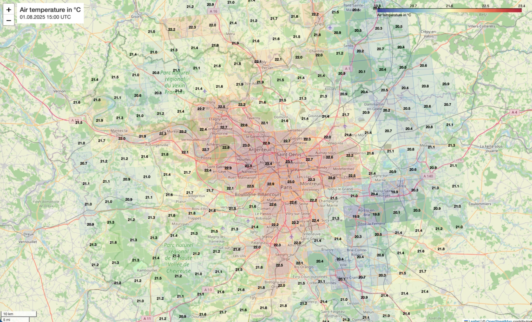
Die mit hostrada4py aus CERRA-Wetterdaten erzeugte Karte zeigt die räumliche Verteilung der Lufttemperatur am 1. August 2025 um 15:00 UTC. Farbflächen und beschriftete Rasterwerte machen regionale Temperaturunterschiede im Stadtgebiet und im Umland unmittelbar vergleichbar. Generated with hostrada4py from CERRA weather data, the map shows the spatial distribution of air temperature on 1 August 2025 at 15:00 UTC. Coloured areas and labelled grid values make regional temperature differences across the city and its surroundings directly comparable.
HOSTRADA bietet die feinere räumliche und zeitliche Auflösung für Deutschland. CERRA erweitert dieselben Analysekonzepte auf Europa und reicht zeitlich bis 1984 zurück.HOSTRADA provides finer spatial and temporal resolution for Germany. CERRA extends the same analysis concepts to Europe and reaches back to 1984.
hostrada4py
Je nach Aufgabe nutzt die Bibliothek HOSTRADA für hochaufgelöste Deutschland-Analysen oder CERRA für europaweite Auswertungen — mit denselben nachvollziehbaren Konzepten für Punkt, Fläche und Route.Depending on the task, the library uses HOSTRADA for high-resolution analyses in Germany or CERRA for Europe-wide evaluations — with the same transparent point, area and route concepts.
Koordinaten, Datenbasis, Klimaparameter und Zeitraum definieren — die Punktauswertung findet die passende Rasterzelle und liefert je nach Quelle eine stündliche HOSTRADA- oder dreistündliche CERRA-Zeitserie.Define coordinates, data source, climate parameter and period — the point workflow finds the matching grid cell and returns an hourly HOSTRADA or three-hourly CERRA time series, depending on the source.
Polygone ausschneiden und räumliche Felder auswerten: im 1-km-HOSTRADA-Raster für Deutschland oder im 5,5-km-CERRA-Raster für Europa — exportierbar als GeoDataFrame, GeoJSON, CSV oder interaktive Karte.Clip polygons and evaluate spatial fields: on the 1 km HOSTRADA grid for Germany or the 5.5 km CERRA grid for Europe — exportable as GeoDataFrame, GeoJSON, CSV or interactive map.
Standortbezogene Klimadaten direkt in die benötigten Formate überführen: EnergyPlus (EPW), IDA ICE (PRN), Polysun (CSV) und Modelica BuildingSystems (CSV).Convert location-based climate data directly into the required formats: EnergyPlus (EPW), IDA ICE (PRN), Polysun (CSV) and Modelica BuildingSystems (CSV).
Ordne jedem Wegpunkt und Zeitstempel die passenden Klimawerte zu. HOSTRADA eignet sich für detaillierte Routen in Deutschland; CERRA ermöglicht grenzüberschreitende Fahrten, Bahnreisen, Fahrradrouten oder Fußwege in ganz Europa.Assign matching climate values to every waypoint and timestamp. HOSTRADA supports detailed routes in Germany, while CERRA enables cross-border vehicle, rail, bicycle and pedestrian journeys across Europe.
Untersuche Beginn, Maximum und Abklingen von Hitzewellen oder anderen Ereignissen. Mit CERRA lassen sich solche Verläufe seit 1984 auch über Ländergrenzen hinweg vergleichen.Study the onset, peak and decay of heat waves or other events. With CERRA, such sequences can also be compared across national borders from 1984 onwards.
pandas, xarray, GeoPandas, Matplotlib, Plotly und Folium verbinden Download, Auswertung, Visualisierung und Export in einem transparenten Workflow.pandas, xarray, GeoPandas, Matplotlib, Plotly and Folium connect download, analysis, visualisation and export in a transparent workflow.
Workflow
hostrada4py übernimmt die wiederkehrenden Schritte zwischen den Datenangeboten von DWD beziehungsweise Copernicus und der Analyse. Die gewählte Quelle bestimmt Abdeckung und Auflösung; Download, Zuschnitt, Auswertung und Export bleiben als einheitlicher Workflow nachvollziehbar.hostrada4py handles the recurring steps between DWD or Copernicus data services and the analysis. The selected source determines coverage and resolution, while download, subsetting, evaluation and export remain one consistent workflow.
Python API
Die folgenden Beispiele orientieren sich an den Modulen und Notebooks des Projekts.The following examples reflect the modules and notebooks included in the project.
$ git clone https://github.com/UdK-VPT/hostrada4py.git
$ cd hostrada4py
$ pip install -e .
from hostrada4py import hostradaPoint as hp

df = hp.extract_values_for_point(
    var="tas",
    lon=13.405,
    lat=52.520,
    start="2025-07-01 00:00",
    end="2025-07-07 23:00",
)

print(df[["time", "tas"]].head())from hostrada4py import hostradaArea as ha
berlin = [
(13.09, 52.34),
(13.76, 52.34),
(13.76, 52.68),
(13.09, 52.68),
]
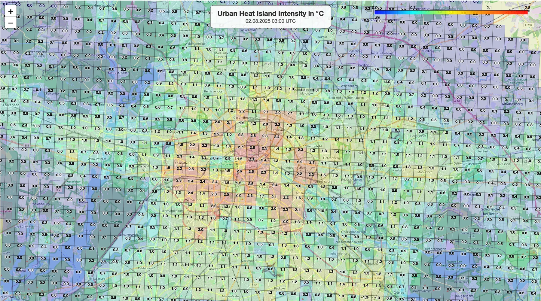
gdf = ha.extract_values_for_polygon(
var="uhi",
polygon_lonlat=berlin,
start_utc="2025-08-02 03:00",
end_utc="2025-08-02 03:00",
return_geodataframe=True,
)from hostrada4py import hostrada_EnergyPlus_Weather as epw
epw.create_energyplus_weather_file(
lon=13.405,
lat=52.520,
start="2025-01-01 00:00",
end="2025-12-31 23:00",
output_file="HOSTRADA_Berlin.epw",
tz="Europe/Berlin",
)from hostrada4py.hostradaRoute import calculate_route_climate
result = calculate_route_climate(
route="route_positions.csv",
variables=["tas", "hurs", "sfcWind"],
timezone="Europe/Berlin",
interpolation="linear",
output_csv="route_climate.csv",
)from hostrada4py import hostradaPoint as hp
from hostrada4py import hostrada_HeatPeriodsGermany as heat
event = heat.heat_periods_germany["events"][0]
site = event["measurement_sites"][0]
df = hp.extract_values_for_point(
var="tas", lon=site["longitude"], lat=site["latitude"],
start=event["core_period"]["start"],
end=event["core_period"]["end"],
)Kontakt & EntwicklungContact & development
hostrada4py wird am Fachgebiet Versorgungsplanung und Versorgungstechnik der Universität der Künste Berlin entwickelt. Beiträge, Issues und fachlicher Austausch sind willkommen.hostrada4py is developed by the Chair of Building Services Engineering at Berlin University of the Arts. Contributions, issues and professional exchange are welcome.
E-Mail schreibenSend an email
Fachgebiet Versorgungsplanung und Versorgungstechnik
Chair of Building Services Engineering
Institut für Architektur und Städtebau
Institute of Architecture and Urban Planning
Universität der Künste Berlin
Rechtliche AngabenLegal information
Körperschaft des öffentlichen Rechts
gesetzlich vertreten durch den Präsidenten Prof. Dr. Markus Hilgert
Prof. Dr. Markus Hilgert
Corporation under public law
legally represented by the President, Prof. Dr. Markus Hilgert
Prof. Dr. Markus Hilgert
Die Universität der Künste (UdK) Berlin übernimmt keine Gewähr für die Aktualität, Richtigkeit und Vollständigkeit der auf dieser Website bereitgestellten Angaben. Dies gilt im besonderen Maße für die Inhalte externer Internetseiten, auf die über Hyperlinks direkt oder indirekt verwiesen wird und die von der UdK Berlin nicht beeinflusst werden können. Die von den Fakultäten, Instituten und weiteren Einrichtungen unterbreiteten Angebote unterliegen der Verantwortung der jeweiligen Bereiche.
Der Inhalt dieser Website ist urheberrechtlich geschützt. Die Vervielfältigung oder Verbreitung der auf dieser Seite bereitgestellten Informationen bedarf der vorherigen schriftlichen Genehmigung durch die UdK Berlin.
Berlin University of the Arts (UdK Berlin) accepts no liability for the timeliness, accuracy or completeness of the information provided on this website. This applies in particular to content on external websites referenced directly or indirectly through hyperlinks and over which UdK Berlin has no control. Content provided by faculties, institutes and other organisational units is the responsibility of the respective unit.
The content of this website is protected by copyright. Reproduction or distribution of the information provided on this page requires the prior written permission of UdK Berlin.